|
The Small Bay "Sébastien
Cholet"
When reading the deed of January 20th 1707 whereby Sébastien
Cholet bought his land bordering on Lake Saint-Louis above La Chine
(Lachine now, but written in two words then because it was thought that China
had been reached), it is difficult to locate this land exactly on a map of the
island of Montreal. But there exists fortunately a map titled Isle de Montréal
1702) drawn up by the sulpician priest Vachon de Belmont. The names of the
owners of the different lands or concessions are indicated but that of Sébastien
Cholet is obviously absent. Luckily, the deed of January 20th 1707
indicates the names of the immediate neighbours, Mathurin Chartier dit
Lamarche on one side and Dubois on the other. These two names appear on the
map of 1702 and enable us to locate precisely the land of Sébastien Cholet
between those of Chartier and Dubois. The name of Jean Reynier does not appear
on the map either but rather that of La Faye who was then the owner. The deed
in question mentions the fact that Reynier had bought the land from La Faye.
The above information was transmitted in November 1984 to the Toponymy
Commission of the Quebec Government so that some geographical entity, if
possible, be designated Sébastien Cholet in memory of our ancestor.
After studying the facts the Commission was in a position to act. Its
president, François Beaudin, in his letter of January 29th 1985 to
Gaston Cholette, then president of the Commission for the Protection of the
French Language, wrote as follows :
In the course of the month of November 1984, you transmitted a
request to the Toponymy Commission to the effect that a tribute be paid to
your ancestor Sébastien Cholette dit Laviolette. At their meeting of January
17th 1985 the commissioners have made official the toponym Anse
Sébastien Cholet. (The word anse means a small bay). This
hydrographic entity is located in Dorval, east of Valois Bay.
As it was your desire we have accepted the idea of honouring this
personage, having in mind the location of his land on the island of Montreal,
at the city limits of Pointe-Claire and Dorval.
(See the topographic map in annex).
Hoping that this homage to your ancestor is up to your expectations, I
beg you, sir, to accept the expression of my best wishes. The map mentioned above is that
reproduced here. By comparing it to the map of Montreal for 1702
it can be seen that Sébastien Cholets land, on the present map, is
located between the Bay of Valois and the small bay indicated as Anse Sébastien
Cholet, more precisely at the place shown as Pointe de Valois.
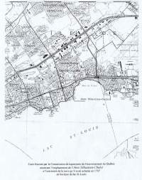
The
Large Bay, which was a point of reference in locating the lands referred
to in the various deeds mentioned, has become with time Valois Bay. It can be
noted that Sébastien Cholets land, formerly in the territory of
Pointe-Claire, is now in Dorval at the city limits with Pointe-Claire.
Referring again to the topographic map it can be seen that the extremity
of Sébastien Cholets land is now part of the territory of Montreal/Dorvals
international airport. |